Scoping Urban Hazards in Kenya and Malawi
Technically I had been to Nairobi before our last trip last month, so I replied yes when people there asked. But then I told them it was when I was two years old and they laughed about how that didn’t count – partly because I can’t remember a thing from that time and partly because the city has changed so much. Back in 1982, the population of the city was around 900,000 but today it is over 3 million, and possibly up nearer 4 million during the day as people come into the city to work.
I was in Nairobi with colleagues Bruce Malamud and Faith Taylor on an initial research trip for our work on the physical dimensions of hazards in urban areas of Africa. During a meeting on the trip at Mzuzu University near another of our study sites – Karonga in Malawi – someone asked why we were focusing on hazards in urban areas particularly. The answer is partly because of the growth exemplified by Nairobi; Africa is urbanising rapidly and estimates are that 56% of the population of African will be urban by the middle of the century.
The UrbanARK project aims to generate knowledge and build capacity to support the growing need for disaster risk reduction strategies for urban populations in sub-Saharan Africa. The component of the project is predominantly driven by a physical science perspective, building on computer simulation and other modelling, to investigate physical hazards and impacts. Our trip was really a scoping exercise to refine our methodology, and to meet local collaborators in our case study cities.
Depending on whose estimates one chooses, Nairobi today is around the 12th largest city in Africa. During our three days there - negotiating the traffic which at times can be debilitating - we met with various regional and city officials to discuss hazards experienced in the city, how they are planned for, managed and mitigated against.
Flash flooding in the lower-lying areas of the city as water flows down from the upland areas is a primary hazard, exacerbated by informal settlements as people construct dwellings on the available space rivers and streams. Many of these areas are really slums and on one day of our trip we visited some of these areas, including Kibera, said by some to be the largest slum in Africa covering 4.5 sq km and housing more than half a million people.
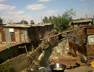
A stream running through Kibera
One of the many problems in these informal settlements, and another which increases problems of flooding, is solid waste management. The researchers at the African Population and Health Research Center involved in the UrbanARK project will focus on this issue, and we saw examples of how discarded waste can block what planned (or unplanned) drainage provision exists. Understanding how these elements of physical interactions between human infrastructure and natural processes (such as overland flow) is important if such issues are to be meaningfully addressed.
Whilst in Nairobi we also visited the Kenya Red Cross to discuss hazards they help to deal with in the city and heard about their current work on fires in informal settlements. One project they are currently working on aims to install smart, web-enabled fire (heat) sensors in houses in informal settlements to provide an early warning system. Fires in informal settlements can spread quickly because of the construction materials used and the high density of buildings. These fires frequently cause loss of life and it is hoped that by creating a network of sensors able to send text message alerts to locals, fires can be more effectively dealt with and risk can be reduced.
A final stop in Nairobi before we travelled onwards to Malawi was to visit the Regional Centre for Mapping of Resources for Development to find out what sorts of spatial information is being collected and used across sub-Saharan Africa. Interestingly, while there we found out more there about data and tools for Malawi than for Kenya. For example, we discovered the newly launched Malawi Hazards and Vulnerability Atlas which looks like a very useful tool at the country-level for assessing risks from a variety of hazards. As is often the case, however, the tool does not focus specifically on urban issues, but it was useful to think about on the flight south past Mount Kilimanjaro and crossing Lake Malawi.
From Malawi’s capital Lilongwe, we immediately headed north to Mzuzu to link up with colleagues involved with UrbanARK at Mzuzu University. The Malawi case study city is not actually Mzuzu itself but the smaller town of Karonga on the shore of Lake Malawi yet further north. Before we continued to Karonga to better understand issues in the town, we discussed the most important hazards faced there - flooding, earthquakes, strong winds and lightning.
On reaching Karonga, the ways in which these hazards are manifest in the town became clearer. Karonga is much smaller than Nairobi and although it will never reach the same scale, it is expected to grow over the coming years. Currently with a population of around 50,000 (expected to grow to 72,000 by 2022), the town feels much less dense than parts of Nairobi (like Kibera). The primary means of transport in Karonga is bicycle, meaning the traffic jams experienced in Nairobi are largely absent (although driving past the market in the evening can be slower than walking as pedestrians outnumber cars by probably more than 100 to 1). Houses in town are generally made of brick and are separated by small yards, but the poverty is on a similar level to the deprived areas of our bigger case study city. As a whole Malawi is poorer compared to Kenya (GNP of $715 per capita vs $2,157) with a lower human development index (0.414 vs 0.535) and a greater proportion of the population are in multidimensional poverty (67% vs 48%).
With the North Rukuru River flowing down from hills 20km to the west and forming the northern boundary of the town, flooding has been a long standing issue in Karonga. To mitigate against this, the centre of town was moved away from the lake shore in the early 1990s, meaning there is now ‘new town’ and ‘old town’ (although the more flood-prone old town is still largely populated). The remainder of Karonga is protected by an earthen dyke to the north, but the construction of a higher road embankment at the east end, combined with local removing some parts of the dyke for building materials, means that flood waters can still overtop or circumvent the dyke. We got an interesting look at the original plans for the dyke in the local planning office and walked sections of the dyke with our collaborators (tailed by a large group of local kids – we were the entertainment for the afternoon!)
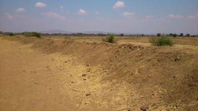
The dyke at Karonga
Another issue for Karonga is the recurrence of earthquakes (or tremors), situated as it is on the Livingstone fault that forms the Great African Rift valley and Lake Malawi itself. We saw some evidence of the quake that struck in 2009, causing an uplift of the main road through town and cracks in some buildings. Other hazards we discussed with local charity organisations included strong winds and hailstorms.
On reflection, although there are clear differences between our two case study cities there are common issues. In both places, well-meaning plans that aim to reduce risks posed by physical hazards are often confounded by informal settlements that spring up wherever people can best make a living with what little they have. In both urban centres the problem of flooding in lower-lying areas arises as water flowing from upland areas inundates land on which ideally people would not be living but which by necessity (due to lack of space) or convenience (proximity to fertile soils) means that they do. Although Nairobi often felt more chaotic than Karonga, this may simply have been because the population (and motorised traffic) density is so much greater; interactions between uncoordinated actions seem to abound in both, often reinforcing and exacerbating existing risks. These issues seem to be particularly African in the context of physical hazards in urban areas.
It was over 30 years between my first two visits to Nairobi, but my next visit will likely be a lot sooner than 2045. By that year Nairobi (and Karonga) will have continued to change but hopefully for the better for the majority of people, and in ways that mitigate risks from physical hazards.
Photos on Flickr from Nairobi and Malawi
I was in Nairobi with colleagues Bruce Malamud and Faith Taylor on an initial research trip for our work on the physical dimensions of hazards in urban areas of Africa. During a meeting on the trip at Mzuzu University near another of our study sites – Karonga in Malawi – someone asked why we were focusing on hazards in urban areas particularly. The answer is partly because of the growth exemplified by Nairobi; Africa is urbanising rapidly and estimates are that 56% of the population of African will be urban by the middle of the century.
The UrbanARK project aims to generate knowledge and build capacity to support the growing need for disaster risk reduction strategies for urban populations in sub-Saharan Africa. The component of the project is predominantly driven by a physical science perspective, building on computer simulation and other modelling, to investigate physical hazards and impacts. Our trip was really a scoping exercise to refine our methodology, and to meet local collaborators in our case study cities.
Depending on whose estimates one chooses, Nairobi today is around the 12th largest city in Africa. During our three days there - negotiating the traffic which at times can be debilitating - we met with various regional and city officials to discuss hazards experienced in the city, how they are planned for, managed and mitigated against.
Flash flooding in the lower-lying areas of the city as water flows down from the upland areas is a primary hazard, exacerbated by informal settlements as people construct dwellings on the available space rivers and streams. Many of these areas are really slums and on one day of our trip we visited some of these areas, including Kibera, said by some to be the largest slum in Africa covering 4.5 sq km and housing more than half a million people.

One of the many problems in these informal settlements, and another which increases problems of flooding, is solid waste management. The researchers at the African Population and Health Research Center involved in the UrbanARK project will focus on this issue, and we saw examples of how discarded waste can block what planned (or unplanned) drainage provision exists. Understanding how these elements of physical interactions between human infrastructure and natural processes (such as overland flow) is important if such issues are to be meaningfully addressed.
Whilst in Nairobi we also visited the Kenya Red Cross to discuss hazards they help to deal with in the city and heard about their current work on fires in informal settlements. One project they are currently working on aims to install smart, web-enabled fire (heat) sensors in houses in informal settlements to provide an early warning system. Fires in informal settlements can spread quickly because of the construction materials used and the high density of buildings. These fires frequently cause loss of life and it is hoped that by creating a network of sensors able to send text message alerts to locals, fires can be more effectively dealt with and risk can be reduced.
A final stop in Nairobi before we travelled onwards to Malawi was to visit the Regional Centre for Mapping of Resources for Development to find out what sorts of spatial information is being collected and used across sub-Saharan Africa. Interestingly, while there we found out more there about data and tools for Malawi than for Kenya. For example, we discovered the newly launched Malawi Hazards and Vulnerability Atlas which looks like a very useful tool at the country-level for assessing risks from a variety of hazards. As is often the case, however, the tool does not focus specifically on urban issues, but it was useful to think about on the flight south past Mount Kilimanjaro and crossing Lake Malawi.
From Malawi’s capital Lilongwe, we immediately headed north to Mzuzu to link up with colleagues involved with UrbanARK at Mzuzu University. The Malawi case study city is not actually Mzuzu itself but the smaller town of Karonga on the shore of Lake Malawi yet further north. Before we continued to Karonga to better understand issues in the town, we discussed the most important hazards faced there - flooding, earthquakes, strong winds and lightning.
On reaching Karonga, the ways in which these hazards are manifest in the town became clearer. Karonga is much smaller than Nairobi and although it will never reach the same scale, it is expected to grow over the coming years. Currently with a population of around 50,000 (expected to grow to 72,000 by 2022), the town feels much less dense than parts of Nairobi (like Kibera). The primary means of transport in Karonga is bicycle, meaning the traffic jams experienced in Nairobi are largely absent (although driving past the market in the evening can be slower than walking as pedestrians outnumber cars by probably more than 100 to 1). Houses in town are generally made of brick and are separated by small yards, but the poverty is on a similar level to the deprived areas of our bigger case study city. As a whole Malawi is poorer compared to Kenya (GNP of $715 per capita vs $2,157) with a lower human development index (0.414 vs 0.535) and a greater proportion of the population are in multidimensional poverty (67% vs 48%).
With the North Rukuru River flowing down from hills 20km to the west and forming the northern boundary of the town, flooding has been a long standing issue in Karonga. To mitigate against this, the centre of town was moved away from the lake shore in the early 1990s, meaning there is now ‘new town’ and ‘old town’ (although the more flood-prone old town is still largely populated). The remainder of Karonga is protected by an earthen dyke to the north, but the construction of a higher road embankment at the east end, combined with local removing some parts of the dyke for building materials, means that flood waters can still overtop or circumvent the dyke. We got an interesting look at the original plans for the dyke in the local planning office and walked sections of the dyke with our collaborators (tailed by a large group of local kids – we were the entertainment for the afternoon!)

Another issue for Karonga is the recurrence of earthquakes (or tremors), situated as it is on the Livingstone fault that forms the Great African Rift valley and Lake Malawi itself. We saw some evidence of the quake that struck in 2009, causing an uplift of the main road through town and cracks in some buildings. Other hazards we discussed with local charity organisations included strong winds and hailstorms.
On reflection, although there are clear differences between our two case study cities there are common issues. In both places, well-meaning plans that aim to reduce risks posed by physical hazards are often confounded by informal settlements that spring up wherever people can best make a living with what little they have. In both urban centres the problem of flooding in lower-lying areas arises as water flowing from upland areas inundates land on which ideally people would not be living but which by necessity (due to lack of space) or convenience (proximity to fertile soils) means that they do. Although Nairobi often felt more chaotic than Karonga, this may simply have been because the population (and motorised traffic) density is so much greater; interactions between uncoordinated actions seem to abound in both, often reinforcing and exacerbating existing risks. These issues seem to be particularly African in the context of physical hazards in urban areas.
It was over 30 years between my first two visits to Nairobi, but my next visit will likely be a lot sooner than 2045. By that year Nairobi (and Karonga) will have continued to change but hopefully for the better for the majority of people, and in ways that mitigate risks from physical hazards.
Photos on Flickr from Nairobi and Malawi

This work by James D.A. Millington is licensed under a Creative Commons Attribution-Noncommercial-Share Alike 3.0 United States License.
posted by James at Monday, September 21, 2015
![]()
![]()


0 Comments:
Post a Comment
<< Home