Characterizing wildfire regimes in the United States
This post is my second contribution to JustScience week, and follows on from the first post yesterday.
During my Master's Thesis I worked with Dr. Bruce Malamud to examine wildfire frequency-area statistics and their ecological and anthropogenic drivers. Work resulting from this thesis led to the publication of Malamud et al. 2005
We examined wildfires statistics for the conterminous United States (U.S.) in a spatially and temporally explicit manner. Using a high-resolution data set of 88,916 U.S. Department of Agriculture Forest Service wildfires over the time period 1970-2000 to consider wildfire occurrence as a function of biophysical landscape characteristics. We used Bailey's ecoregions as shown by Figure 1A below.
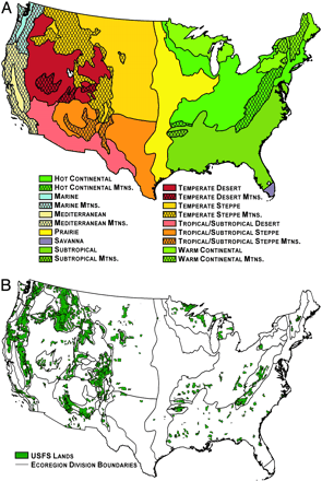
Figure 1.
In Bailey's classification, the conterminous U.S. is divided into ecoregion divisions according to common characteristics of climate, vegetation, and soils. Mountainous areas within specific divisions are also classified. In the paper, we used ecoregion divisions to geographically subdivide the wildfire database for statistical analyses as a function of ecoregion division. Figure 1B above shows the location of USFS lands in the conterminous U.S.
We found that wildfires exhibit robust frequency-area power-law behaviour in the 18 different ecoregions and used power-law exponents (normalized by ecoregion area and the temporal extent of the wildfire database) to compare the scaling of wildfire-burned areas between ecoregions. Normalizing the relationships allowed us to map the frequency-area relationships, as shown in Figure 2A below.
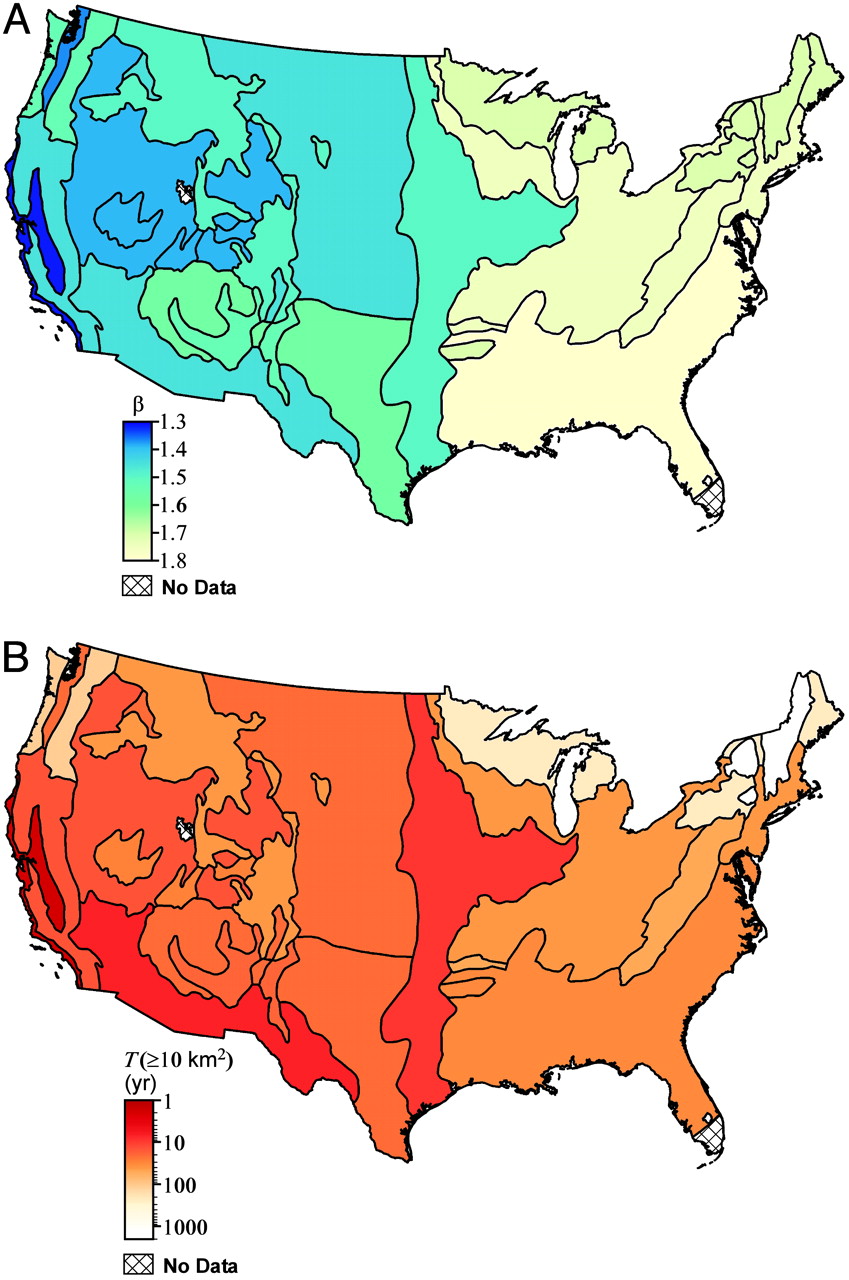
Figure 2.
This mapping exercise shows a systematic change east-to-west gradient in power-law exponent beta values. This gradient suggests that the ratio of the number of large to small wildfires decreases from east to west across the conterminous U.S. Controls on the wildfire regime (for example, climate and fuels) vary temporally, spatially, and at different scales, so it is difficult to attribute specific causes to this east-to-west gradient. We suggested that the reduced contribution of large wildfires to total burned area in eastern ecoregion divisions might be due to greater human population densities that have increased forest fragmentation compared with western ecoregions. Alternatively, the gradient may have natural drivers, with climate and vegetation producing conditions more conducive to large wildfires in some ecoregions compared with others.
Finally, this method allowed us to calculate recurrence intervals for wildfires of a given burned area or larger for each ecoregion (Figure 2B above). In turn this allowed for the classification of wildfire regimes for probabilistic hazard estimation in the same vein as is now used for earthquakes.
Read the full paper here.
Technorati Tags: wildfire, statistics, mapping, risk, hazard
During my Master's Thesis I worked with Dr. Bruce Malamud to examine wildfire frequency-area statistics and their ecological and anthropogenic drivers. Work resulting from this thesis led to the publication of Malamud et al. 2005
We examined wildfires statistics for the conterminous United States (U.S.) in a spatially and temporally explicit manner. Using a high-resolution data set of 88,916 U.S. Department of Agriculture Forest Service wildfires over the time period 1970-2000 to consider wildfire occurrence as a function of biophysical landscape characteristics. We used Bailey's ecoregions as shown by Figure 1A below.
Figure 1.
In Bailey's classification, the conterminous U.S. is divided into ecoregion divisions according to common characteristics of climate, vegetation, and soils. Mountainous areas within specific divisions are also classified. In the paper, we used ecoregion divisions to geographically subdivide the wildfire database for statistical analyses as a function of ecoregion division. Figure 1B above shows the location of USFS lands in the conterminous U.S.
We found that wildfires exhibit robust frequency-area power-law behaviour in the 18 different ecoregions and used power-law exponents (normalized by ecoregion area and the temporal extent of the wildfire database) to compare the scaling of wildfire-burned areas between ecoregions. Normalizing the relationships allowed us to map the frequency-area relationships, as shown in Figure 2A below.
Figure 2.
This mapping exercise shows a systematic change east-to-west gradient in power-law exponent beta values. This gradient suggests that the ratio of the number of large to small wildfires decreases from east to west across the conterminous U.S. Controls on the wildfire regime (for example, climate and fuels) vary temporally, spatially, and at different scales, so it is difficult to attribute specific causes to this east-to-west gradient. We suggested that the reduced contribution of large wildfires to total burned area in eastern ecoregion divisions might be due to greater human population densities that have increased forest fragmentation compared with western ecoregions. Alternatively, the gradient may have natural drivers, with climate and vegetation producing conditions more conducive to large wildfires in some ecoregions compared with others.
Finally, this method allowed us to calculate recurrence intervals for wildfires of a given burned area or larger for each ecoregion (Figure 2B above). In turn this allowed for the classification of wildfire regimes for probabilistic hazard estimation in the same vein as is now used for earthquakes.
Read the full paper here.
Technorati Tags: wildfire, statistics, mapping, risk, hazard
Labels: Academic, Ecological, Environmental, Geographic, Modelling, Publications, Statistical, Wildfire

This work by James D.A. Millington is licensed under a Creative Commons Attribution-Noncommercial-Share Alike 3.0 United States License.
posted by James at Tuesday, February 06, 2007
![]()
![]()


0 Comments:
Post a Comment
<< Home